Hydrology
Detailed hydrologic assessments
Hydrologic analysis is all about understanding the water balance of a catchment.
At its broadest, the hydrology of a catchment may include many aspects of the water balance. These include: precipitation; stream flow; groundwater; and evaporation from the soil and plants. There may also be human factors, such as: groundwater extraction; irrigation; import and export of water; collection and storage of water; and modifications to the ground surface.
Important aspects of a catchment’s water balance will also vary with scale. At the river catchment scale, we are more likely to be interested in the bigger flows – rainfall, streamflow and evaporation. On a mine site or in an industrial or urban area, key water balance aspects may relate more to water movement and use by industries and people. For design or flood risk studies, hydrology involves characterising flood flow rates from a catchment.
What we do
We focus on surface water aspects of the water balance. For larger catchments, usually we are interested in deriving stream flow data for input to design projects or flood risk assessments.
Hydrologic analysis often includes quite a bit of catchment characterisation, including topography, streamline characteristics and land use/vegetation. It often includes management of large data sets, including spatial data (such as rainfall radar data or topographic survey) and time series data (streamflow or rainfall). We then need to understand and interrogate these data. We use advanced data management and numerical techniques to do this.
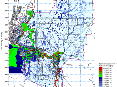
We use models quite a lot to help characterise catchment hydrology. All hydrologic modelling is complex, but the models we use vary from simple formulations to detailed, spatially realistic models. Examples include application of statistical models to derive design flows for a catchment (such as a regional flood frequency method), catchment based routing models (such as RORB) and rain-on-grid models (such as DHI Mike SHE).

